Pileus clouds are lens-shaped clouds that form above the tops of larger cumulus or cumulonimbus clouds. Pileus clouds have attributes including their appearance, formation process, duration, and associated weather conditions. Pileus clouds occur at certain altitudes and are composed of water droplets or ice crystals. Learn about pileus clouds’ size, shape, color, and frequency of occurrence. Pileus clouds impact weather patterns and serve as indicators of instability. Pileus clouds relate to vertical air movement and the development of thunderstorms.
Pileus clouds form when rising cumuliform clouds cause air at the top to cool and condense. Cooled and condensed air creates a cloud attached to the tower’s summit. Upward thrusting creates updrafts of air, reaching speeds of 100 mph (160.9 km/h) or more in thunderstorms. Moist air hits a layer of air above and reaches its dew point, forming the smooth, rounded shape of the pileus cloud. Ascending air reaches its dew point at altitudes above 6,500 feet (1,981 meters). Water vapor in the air condenses into water droplets or ice crystals, releasing latent heat that fuels the updraft.
Pileus clouds are composed of ice crystals and water droplets. Ice crystals in pileus clouds measure between 0.01-10 mm (0.0004-0.39 inches) in diameter. Pileus clouds appear gray in color with a flat base and rounded top. Pileus clouds form when supercooled water droplets freeze onto falling ice crystals. Pileus clouds exhibit iridescence due to their uniform composition of ice crystals.
Pileus clouds are classified as tropospheric clouds, forming at altitudes ranging from hundreds to thousands of meters above the Earth’s surface. Pileus clouds have base heights of 2-5 kilometers (1.2-3.1 miles) and top heights of 5-10 kilometers (3.1-6.2 miles) above ground level. Pileus clouds measure less than 1 mile (less than 1.61 kilometers) in diameter and less than 100 meters (less than 328.08 feet) in thickness. Pileus clouds persist for 10-15 minutes before being absorbed into the cloud structure. Pileus clouds indicate thunderstorm development and are considered a sign of a developing storm by meteorologists. Presence of pileus clouds indicates strong upward motion in the atmosphere, of cumuliform cloud development.
What is a pileus cloud?
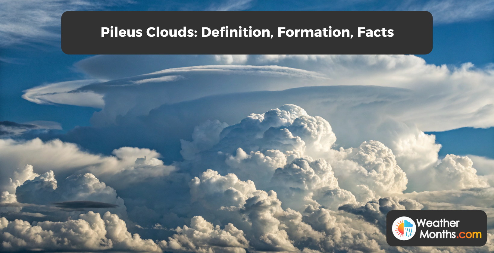
A pileus cloud is a lenticular cloud that appears as a rounded cap on top of a cumulus or cumulonimbus cloud and is called a scarf cloud or cloud cap. Pileus clouds form when a layer of cool air becomes trapped beneath warm air, creating a zone of instability. Pileus clouds appear in conjunction with thunderstorms, indicating the presence of updrafts. Pileus clouds last for minutes and have a horizontal extent of less than 1 km (0.62 miles). Pileus clouds are classified as accessory clouds, forming in the upper parts of cumuliform clouds. The main cloud penetrates the pileus cloud as it continues to grow vertically.
What type of weather is associated with pileus clouds?
The type of weather associated with pileus clouds is severe thunderstorms, characterized by strong updrafts and convection, forming on top of growing cumulus or cumulonimbus clouds. Pileus clouds form atop growing cumulus or cumulonimbus calvus clouds due to strong updrafts. Severe thunderstorms produce pileus clouds as an indicator of their development. Cumulonimbus incus clouds with anvil-shaped tops display pileus formations. Meteorologists use pileus cloud observations to predict potential severe weather events. Mid-latitude regions such as the United States, Europe, and Australia experience pileus cloud formations during thunderstorm seasons.
Pileus clouds are indicators of approaching severe weather. Cumulus clouds transform into cumulonimbus clouds within 30 minutes of pileus formation in 75% of cases. Cumulonimbus clouds develop, bringing heavy rain, hail, lightning, and strong winds. Pileus clouds form under specific atmospheric conditions conducive to severe weather. Updrafts reach speeds up to 100 km/h (62 mph), lifting moist air into upper atmosphere levels. Atmospheric instability allows pileus cloud formation at altitudes above 32,808 feet (10,000 meters). Rising moist air creates instability areas with humidity values reaching 80% or higher.
Weather conditions worsen after pileus cloud appearance. Cumulonimbus clouds grow to heights over 18,000 meters ( 59,055 feet), producing thunderstorms. Pileus clouds atop cumulonimbus formations indicate cloud maturity and imminent severe weather. Pileus clouds forming above 10,000 meters (32,808 feet) are associated with severe thunderstorms. Wind shear occurs during pileus cloud formation, with wind speeds increasing with height. Observers must seek shelter upon seeing pileus clouds due to the likelihood of dangerous weather conditions developing.
How do pileus clouds form?
Pileus clouds form when rising cumuliform clouds cause air at the top to cool and condense, creating a smooth, rounded cloud attached to the tower’s summit. Cumuliform clouds thrust upward, creating strong updrafts of moist air. Moist air hits a layer of air above, reaching its dew point. Water vapor condenses, forming the distinctive smooth, rounded shape of the pileus cloud. Pileus clouds attach to the top of the growing cumuliform tower, signaling vertical development. The air mass continues to rise, leading to larger cloud formations.
The initial conditions for pileus cloud formation involve an updraft of moist air and ascent of a cumuliform cloud. Updrafts reach speeds of 100 mph (160.9 km/h) or more in thunderstorms. The rising air pushes against the layer above, forcing air around the cloud top. Air is forced to rise at rates exceeding 15.24 meters per second (50 feet per second) in some cases.
Atmospheric interaction occurs as the rising air cools. Air temperature decreases by 5.4°F (3°C) for every 1,000 feet (304.8 meters) of elevation gain. The ascending air reaches its dew point, at altitudes above 1,981 meters (6,500 feet). Water vapor in the cooled air condenses into water droplets or ice crystals. Condensation releases latent heat, fueling the updraft.
The condensation process forms an umbrella-like shape surrounding the growing cumulonimbus tower. Pileus clouds measure less than 1 mile (less than 1.61 kilometers) in diameter. The cap-like formation develops within minutes as the parent cloud continues to rise.
What do pileus clouds look like?
Pileus clouds look like smooth, cap-like formations that appear on top of cumuliform clouds or thunderstorm towers. Pileus clouds appear white or light gray in color. Meteorologists identify pileus clouds by their distinctive rounded appearance. Cumuliform clouds or thunderstorm towers develop pileus clouds on their tops. Pileus clouds form when cool air becomes trapped beneath warm air. People refer to pileus clouds as “cap clouds” due to their shape.
Pileus clouds exhibit a cap-shaped or hat-like formation. The horizontal cloud base and rounded upper surface create a beret appearance. Pileus clouds resemble a comb-over hairstyle when viewed from the side, with a flat base and curved top.
Pileus clouds present as a thin cloud layer with a lenticular-like appearance. The cap appearance of pileus clouds stands out against the parent cloud below. Pileus clouds have a uniform texture and anvil-shaped structure, displaying iridescent colors that enhance their visual appeal.
What causes a pileus cloud to appear as a rainbow?
A pileus cloud appears as a rainbow when sunlight diffracts through water droplets or ice crystals within the cloud, causing iridescence. Water droplets or ice crystals within pileus clouds measure between 0.5 mm (0.02 in) and 1.5 mm (0.06 in) in diameter. Cloud thinness allows sunlight to pass through and separate into colors. Sunlight must strike the cloud at an angle between 48° and 54° relative to the observer’s position. Observers must be positioned at the angle relative to the sunlight and cloud to see the rainbow effect. Clear atmosphere with minimal aerosol particles enhances the visibility of the rainbow colors in pileus clouds.
Light interaction and scattering play a role in the rainbow appearance of pileus clouds. Sunlight interacts with water droplets or ice crystals within the cloud, causing diffraction and scattering. Water droplets and ice crystals scatter light through Mie scattering, with smaller particles scattering blue wavelengths and larger ones scattering red. Diffraction occurs as light bends around cloud particles, creating interference patterns. Colors manifest due to wavelength separation, resulting in the visible spectrum from red to violet.
Cloud structure and formation contribute to the iridescent effect. Cloud thinness ensures light penetration, allowing sunlight to interact with the particles. Droplets and crystals expose more surface area for light interaction, enhancing the scattering effect. Similar size of particles, between 0.01 to 1 millimeter (0.00039 to 0.039 inches) in diameter, contributes to uniform scattering and iridescence. Updrafts and rising air form pileus clouds, at altitudes above 32,808 feet (10,000 meters). Cooler air clashes with warmer air, creating conditions for pileus cloud formation atop cumulonimbus clouds.
What causes iridescent pileus clouds?
Iridescent pileus clouds are caused by the diffraction of sunlight as it interacts with small water droplets or ice crystals suspended in the atmosphere, creating a rainbow-like play of colors. Pileus clouds form when cool air becomes trapped under warm air, creating a temperature inversion. Water droplets or ice crystals in these clouds measure 10-20 micrometers in diameter. Sunlight enters the cloud at an angle, interacting with the suspended particles. Diffraction scatters the light into individual colors, producing a striking display. Iridescent pileus clouds are visible during late morning or early afternoon when atmospheric conditions are favorable.
Pileus cloud formation begins with strong updrafts in a humid layer of air. Warm air rises, driving the growth of cumulus clouds. The rising air cools and condenses, forming a rounded cloud at the top of the cumulus. Water vapor in the air condenses into water droplets or ice crystals, measuring 0.01 to 1 millimeter (0.00039 to 0.039 inches) in diameter. These uniformly sized particles remain suspended in the air at heights between 2 km (1.24 miles) - 5 km (3.11 miles) above the ground, creating an environment for light diffraction.
Sunlight interacts with the suspended water droplets or ice crystals in the pileus cloud. Light waves scatter and bend around the particles through diffraction. The uniform size and distribution of droplets or ice crystals cause light waves to scatter. Reflection and refraction occur as sunlight passes through the cloud particles. Water droplets reflect and refract light from ice crystals, contributing to the colors and patterns observed in iridescent pileus clouds.
Diffraction and scattering of light waves produce the colors of pileus clouds. Light waves separate into individual colors through dispersion, similar to a prism effect. Small water droplets scatter shorter blue wavelengths more than longer red wavelengths, producing a blue or violet color. Ice crystals scatter light, creating a range of colors depending on the angle of sunlight. The interplay of diffraction, reflection, and refraction results in a display of colors. Mie scattering, named after physicist Gustav Mie, occurs when light waves scatter off spherical particles like water droplets or ice crystals. Mie scattering is responsible for the iridescent colors observed in pileus clouds.
What is a pileus cloud made of?
A pileus cloud is made of ice crystals and water droplets, forming a rounded cap on top of a growing cumulus or cumulonimbus cloud. Ice crystals in pileus clouds measure smaller than 0.5 mm (0.02 inches) in diameter. Meteorologists refer to pileus clouds as “calvus clouds” when they form on top of a cumulonimbus cloud. People observe pileus clouds as a cap on top of a growing cumulus or cumulonimbus cloud, leading to the nickname “cap clouds.”
Pileus clouds are composed of ice crystals. Pileus clouds form as a sheet above cumulus or cumulonimbus clouds. The sheet structure allows pileus clouds to exhibit iridescence due to their uniform composition.
Pileus clouds are classified as tropospheric clouds. Tropospheric clouds form at altitudes ranging from hundreds to thousands of meters above the Earth’s surface.
Rising air above developing clouds results in pileus cloud formation. Rising air pushes into stable moist air layers, causing the moist air to cool and condense. Condensation creates the cap-like formation of pileus clouds. Pileus clouds appear as umbrella or hood shapes above cumulus or cumulonimbus clouds. The smooth appearance results from the rising moist air condensing into visible liquid droplets or ice crystals.
What are the facts about pileus clouds?
Facts about pileus clouds include their formation as small, rounded caps above growing cumulonimbus clouds, indicating potential thunderstorm development and exhibiting iridescence due to ice crystal diffraction. Pileus clouds form at high altitudes, above 20,000 feet (6,000 meters). Meteorologists consider pileus clouds a sign of a developing storm. The appearance of pileus clouds indicates a cumulonimbus cloud is growing beneath it. Convection currents drive the growth of the cumulonimbus cloud and create unstable conditions necessary for pileus cloud formation. Pileus clouds consist of small ice crystals and appear as a horizontal cap or a small mass of cloud.
The facts about pileus clouds are outlined below.
- Pileus clouds are small, rounded caps above growing cumulonimbus clouds.
- Pileus clouds signal possible thunderstorm development.
- Iridescence of pileus clouds is caused by ice crystal diffraction.
- Pileus cloud formation Occurs at high altitudes, above 20,000 feet (6,000 meters).
- Pileus clouds are composed of small ice crystals.
- Pileus clouds appear as cap-shaped or hood-like formations.
- Pileus clouds are short-lived, lasting only a few minutes.
- Presence of pileus clouds shows strong upward motion in the atmosphere.
- Pileus clouds are lenticular formations, less than 1 kilometer wide and less than 100 meters thick.
- Formative process of pileus clouds involves convection and moist air layers lifted by rising cumuliform clouds.
- The appearance of pileus clouds accompanies a growing cumulonimbus cloud beneath them.
- Pileus clouds are considered indicators of developing severe thunderstorms.
Pileus clouds appear in superposition, forming layers on top of each other. The formation process involves rising air around cumuliform towers, creating a thin and horizontal cloud layer. Moist air layers are lifted by the rising cloud below, resulting in a series of cap-shaped clouds.
Pileus clouds are short-lived phenomena, lasting a few minutes. The rising cloud absorbs these formations through convection as it continues to grow. Pileus clouds form at high altitudes, between 2,000 meters (6,562 feet) to 5,000 meters (16,404 feet) above sea level. Their presence indicates strong upward motion in the atmosphere, which is characteristic of cumuliform cloud development. Meteorologists consider pileus clouds as indicators of atmospheric dynamics, in relation to severe thunderstorm development.
Are pileus clouds dangerous?
Pileus clouds are not dangerous, but they are often seen in association with other cloud types that signal impending severe weather. Pileus clouds accompany cumulonimbus formations associated with thunderstorms and rain showers. Meteorologists observe pileus clouds as indicators of rising air currents and atmospheric instability. Weather forecasters use pileus cloud sightings to predict potential severe weather events within the next few hours. Pilots and aviation professionals monitor pileus clouds for flight safety considerations, as they signal turbulent conditions aloft. Emergency management officials consider pileus cloud reports when assessing weather-related risks to communities.