A shelf cloud is a cloud formation associated with thunderstorms. Shelf clouds exhibit a distinctive shape and are characterized by their formation process. Shelf clouds are linked to gusty winds and outflow from thunderstorms. Shelf clouds impact weather conditions and serve as indicators of approaching storms. Understand aspects of shelf clouds to interpret and predict severe weather phenomena.
Shelf clouds differ from wall clouds in appearance and behavior. Shelf clouds form as hanging clouds at the leading edge of thunderstorms, spanning hundred square kilometers. Wall clouds manifest as vertical clouds in the updraft region, covering areas of several square kilometers. Shelf clouds exhibit horizontal axis rotation and move with the storm front at speeds of 18.6 mph (30 km/h) - 31.1 mph (50.1 km/h). Shelf clouds bring winds exceeding 50-60 km/h, precipitation, and hail. Wall clouds indicate tornado formation and updrafts, with wind speeds exceeding 100-150 km/h (62-93 mph).
Shelf cloud formation occurs through the interaction between thunderstorm updrafts and surface air. Cold fronts push warm air upwards, leading to rapid cooling and condensation. Atmospheric instability of 500-1000 J/kg supports shelf cloud development. Shelf clouds indicate lines of thunderstorms associated with winds, rain, and weather conditions.
What is a shelf cloud?
A shelf cloud is a low-hanging, anvil-shaped cloud formation typically associated with the leading edge of thunderstorms, characterized by its shelf-like appearance and indicating the potential for severe weather. Shelf clouds form when thunderstorm updrafts interact with surface air, causing water vapor to condense. Thunderstorm complexes produce shelf clouds near their leading edge, in environments with instability and wind shear. Shelf clouds feature coloration, flat or wavy upper surfaces, and exhibit a greenish tint. Meteorologists consider shelf clouds indicators of potential severe weather, including heavy rain, hail, and strong winds. Storm chasers utilize shelf cloud observations to predict the location and intensity of severe weather events.
The gust front of a thunderstorm forces air upwards. This rising air condenses at the boundary, creating the shelf-like appearance. Shelf cloud structure spans 1-5 km (0.6-3.1 miles) wide and 0.5-2 km (0.3-1.2 miles) high. The cloud layer is characterized by a concentration of water droplets and ice crystals.
Shelf clouds are known for their anvil or shelf-like form. The leading edge features a rounded or wave-like shape, extending several hundred meters high. Shelf cloud appearance includes a base with an anvil-shaped upper surface. Some shelf clouds exhibit a tint in severe thunderstorm conditions. The underside of the shelf cloud appears turbulent due to strong winds associated with the gust front.
Shelf clouds are classified as a type of arcus cloud, forming as clouds to thunderstorm systems. Wall clouds indicate rotation within thunderstorms and are taller and vertical. Shelf clouds mark the boundary between the storm’s outflow and surrounding environment. They precede a line of strong thunderstorms, signaling the approach of damaging straight-line winds and heavy rainfall. Shelf clouds form in stormy environments, including near thunderstorms, derechos, and haboobs.
What is the difference between a shelf cloud and a wall cloud?
The difference between shelf cloud and wall cloud is that shelf clouds appear as horizontal, low-hanging clouds at the leading edge of thunderstorms, while wall clouds manifest as vertical clouds in the updraft region, with the former associated with winds and precipitation, and the latter linked to rotation and tornado formation. Shelf clouds appear as solid, anvil-shaped structures with a rolling appearance. Wall clouds display vertical growth and an anvil-shaped base. Shelf clouds develop in the first 10-15 minutes of a storm’s formation and move at speeds of 30-50 km/h (18-31 mph). Wall clouds form in the updraft region behind the storm’s leading edge and rotate around their vertical axis. Shelf clouds cover areas, spanning several hundred square kilometers, while wall clouds encompass smaller areas of several square kilometers.
The difference between shelf cloud and wall cloud is explained in the table below.
| Aspect | Shelf Cloud | Wall Cloud |
| Location | Leading edge of thunderstorms, 1-5 km ahead of the main storm | Rear flank of supercells, in the updraft region, 1-2 km from the updraft base |
| Appearance | Horizontal, low-hanging, wedge-shaped formations, 1-2 km high, 5-10 km wide | Vertical, lowered, rotating base, 0.5-1.5 km high, 1-3 km wide |
| Structure | Anvil-shaped, rolling appearance, with a flat base and a rounded top | Vertical growth with an anvil-shaped base, with a rounded top and a narrow, tapering base |
| Speed & Movement | Moves at speeds of 30-50 km/h (18-31 mph), with a forward speed of 10-30 km/h (6-18 mph) | Stationary, rotates around vertical axis at 10-30 km/h (6-18 mph) |
| Weather Hazards | Associated with winds >31-37 mph (50-60 km/h), heavy rain, hail, and gust fronts | Indicates tornado formation, wind speeds >62-93 mph (100-150 km/h), and large hail |
| Size & Duration | Spans several hundred square kilometers, lasts 2-6 hours | Encompasses several square kilometers, lasts 10-60 minutes |
| Proximity to Ground | Higher above ground, 1-2 km above ground level | Closer to ground, 0.5-1 km above ground level |
| Occurrence | Common with squall lines, 50-70% of cases | Less frequent, forms in 10-20% of supercell thunderstorms |
| Rotation | Horizontal axis rotation, 10-50 m/s | Vertical axis rotation, 50-100 m/s |
Shelf clouds and wall clouds differ in appearance and structure. Shelf clouds form wedge-shaped formations extending across the sky. Wall clouds manifest as vertical, lowered, rotating bases of thunderstorms. The location and formation within storms vary between these cloud types. Shelf clouds develop at the leading edge of thunderstorms, spanning kilometers. Wall clouds form in the rear flank of supercells, in the updraft region.
Rotation and movement patterns distinguish shelf clouds from wall clouds. Shelf clouds exhibit horizontal axis rotation and move with the storm front at speeds of 18.6-31.1 mph (30-50 km/h). Wall clouds rotate around a vertical axis and remain stationary within the storm. Weather patterns and hazards differ for each cloud type. Shelf clouds bring winds exceeding 31-37 mph (50-60 km/h), heavy precipitation, and hail. Wall clouds indicate tornado formation and intense updrafts, with wind speeds exceeding 62-93 mph (100-150 km/h).
Size, proximity to ground, and duration vary between shelf and wall clouds. Shelf clouds appear higher above ground and last for several hours. Wall clouds are smaller, closer to the ground, and persist for minutes to hours. Frequency of occurrence and predictability differ. Shelf clouds occur and are seen with squall lines. Wall clouds appear less and form in supercell thunderstorms. Meteorologists misreport shelf clouds as wall clouds due to their similar appearance. Accurate identification requires careful analysis of cloud characteristics and associated weather patterns.
What is the difference between a shelf cloud and a roll cloud?
The difference between a shelf cloud and a roll cloud is that shelf clouds are flat, horizontal, and attached to the thunderstorm’s main updraft, while roll clouds are tubular, rolling, and are either attached or detached from the storm. Shelf clouds form at the leading edge of thunderstorms, associated with gust fronts or dry lines. Roll clouds are shorter-lived than shelf clouds. Shelf clouds exhibit an anvil-shaped base with a rolling appearance. Roll clouds display a distinct tubular, wavy shape. Winds, rain, and hail accompany shelf clouds, while roll clouds occur in areas with wind shear.
What is the difference between a shelf cloud and a tornado?
The difference between a shelf cloud and a tornado is that shelf clouds are larger, horizontal cloud formations associated with thunderstorms, while tornadoes are rotating, vertical columns of air with power. Shelf clouds appear as horizontal formations at the leading edge of thunderstorms. Tornadoes form as rotating columns of air extending from storm clouds to the ground. Shelf clouds lack the rotation and vertical growth characteristic of tornadoes. Meteorologist Kate Kealey emphasizes that shelf clouds produce winds and rain but are not tornadoes themselves. Shelf clouds cover larger areas than tornadoes, which are focused and destructive.
Shelf clouds and tornadoes differ in their formation and structure. Shelf clouds lack rotation, while tornadoes have intense rotation. Shelf clouds form on the leading edge of storms, extending for miles. Tornadoes form under the rain-free base of supercells, extending vertically from cloud to ground. Shelf clouds do not touch the ground, remaining elevated above the surface. Tornadoes make contact with the ground, causing destruction at ground level.
Size and associated weather systems distinguish shelf clouds from tornadoes. Shelf clouds are larger, spanning entire counties or states. Tornadoes measure a hundred feet to miles in diameter. Shelf clouds are associated with lines of storms called squall lines. Tornadoes are associated with rotating supercell thunderstorms. Shelf clouds stretch along the leading edge of a storm system. Tornadoes develop in a localized area under a wall cloud within a storm.
Weather impacts and threat levels vary between shelf clouds and tornadoes. Shelf clouds bring strong straight-line winds up to 60 mph (96.56 km/h) and heavy rainfall rates up to 2 inches per hour (50.8 mm/h). Tornadoes produce rotating winds up to 300 mph (483 km/h) capable of severe damage. Shelf clouds indicate severe weather but do not pose an immediate tornado threat. Tornadoes present a danger to life and property. Shelf clouds pass over an area in 10-15 minutes on average. Tornadoes remain on the ground for extended periods, carving long damage paths.
What is the difference between a shelf cloud and a storm?
The difference between a shelf cloud and a storm is that a shelf cloud is a cloud formation associated with the leading edge of a storm system, while a storm encompasses a broader range of weather phenomena including rain, hail, lightning, and winds. Shelf clouds form at the leading edge of thunderstorms. Storms produce a range of severe weather phenomena. Shelf clouds exhibit a rolling or boiling motion. Air movement creates the shelf cloud formation. Dylan Dodson, a meteorologist, emphasizes that shelf clouds are distinct from storms themselves.
Shelf clouds are an integral part of storm systems. Shelf clouds form at the leading edge of storms, appearing 0.6-3.1 miles (1-5 kilometers) ahead of a storm’s main updraft. Shelf clouds serve as an indicator of an approaching storm. The anvil-shaped or rolled appearance of shelf clouds signals the arrival of severe weather. Shelf clouds are classified as cloud formations, while storms are weather events. Storms encompass multiple cloud types, precipitation, and winds. Storms do not produce shelf clouds, but shelf clouds are associated with storms. Shelf clouds form when cool air rises over warm air ahead of an advancing storm front. The rising air creates instability and leads to the formation of the shelf cloud shape. Wall clouds differ from shelf clouds in their orientation and implications. Wall clouds form vertically with thunderstorms and precede tornadoes, while shelf clouds form horizontally at storm leading edges and do not produce tornadoes.
What causes a shelf cloud?
A shelf cloud is caused by the interaction of warm and cold air masses, where a cold front pushes warm air upwards, leading to rapid cooling and condensation. Shelf clouds form in association with thunderstorms, appearing in advance of a cold front or dry line. Cold fronts push warm air upwards, causing it to cool and condense. Warm air ascends and cools as it rises, leading to cloud formation. Water vapor in the rising air condenses as it cools, creating the low-hanging, anvil-shaped structure of a shelf cloud. Shelf clouds possess a flat base and towering vertical growth, signaling an approaching cold front and accompanying winds, rain, and thunderstorms.
Cold air pushes warm air rises up at the leading edge of a thunderstorm. The gust front advances ahead of the storm, displacing surface air. Cooler air descends from the storm’s downdraft, forcing warm air upwards at rates of 0.4-2 in/s. Rising air cools and condenses as it ascends, forming the shelf cloud shape. Water vapor in the lifted air condenses when the humidity reaches 60-80%.
The shelf cloud marks the boundary between cold downdraft air and warm unstable air. Updrafts within the thunderstorm carry warm air upward, while downdrafts of cool air descend and spread outward. The shelf cloud indicates the approaching storm boundary, extending 10-50 miles (16-80 kilometers) ahead of the precipitation. Thunderstorm dynamics create lifting at the gust front, with wind shear of 20-50 knots contributing to shelf cloud formation.
Downdrafts occur in the storm core, bringing cooler air to the surface. Updrafts occur at the leading edge, lifting air to form the shelf cloud. The thunderstorm approaches, creating the shelf cloud structure with its flat, anvil-like shape and rolling base. Atmospheric instability of 500-1000 J/kg supports shelf cloud development as the storm nears. Meteorologists explain shelf clouds form where cool air undercuts warm air along the advancing gust front of thunderstorms.
What does a shelf cloud look like?
A shelf cloud looks like a low-hanging, anvil-shaped cloud with a flat base and rounded upper surface, appearing and extending outward from thunderstorm bases. Shelf clouds form in the first few hours of thunderstorm development. Wind speeds within shelf clouds reach up to 100 km/h (62 mph). Rain rates within shelf clouds are as high as 100 mm/h (3.94 in/h). Shelf clouds measure up to 6.2 miles (10 kilometers) wide and 0.62 miles (1 kilometer) high. Observers must view shelf clouds from a safe distance due to their association with severe weather conditions.
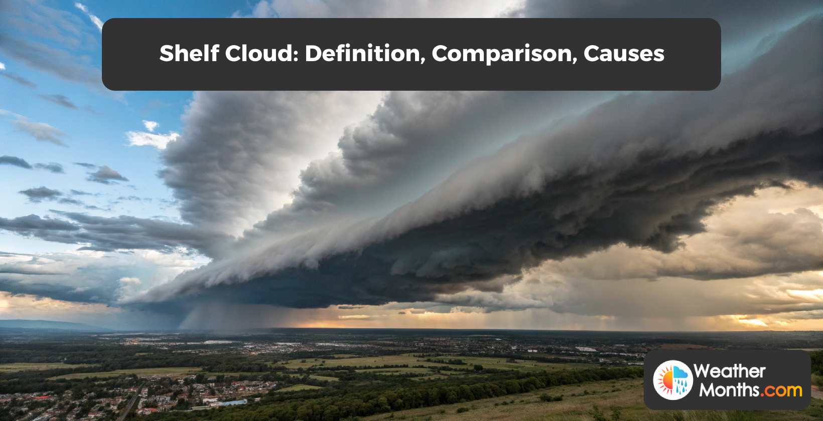
Shelf clouds exhibit a distinctive horizontal shape with a flat base and appearance. The leading edge takes on a wedge-shaped profile, resembling a wall of water or mist stretching across the horizon. These clouds form at levels below 2,000 feet (610 meters), and attach directly to the thunderstorm base. Shelf clouds extend outward from the storm, creating a bar-like or anvil-shaped structure.
Features of shelf clouds include a smooth upper surface contrasted by a turbulent underside. Wave-like patterns appear on the cloud’s surface, resembling ocean waves. Shelf clouds display a tint, indicating the presence of hail or heavy precipitation within the storm system. The cloud formation stretches for miles, with some shelf clouds extending up to 100 miles (161 kilometers) in length.
Shelf clouds demonstrate behavior and movement. Rising motion within the cloud creates areas of turbulence and rotation. The leading edge of shelf clouds moves at speeds up to 50-60 km/h (30-40 mph), covering the horizon in a dramatic display. Shelf clouds are short-lived phenomena, lasting 15-30 minutes. These formations signal the approach of a line of storms or squall line, accompanied by strong winds reaching up to 100-150 km/h (60-90 mph).
What does a shelf cloud indicate?
A shelf cloud indicates an approaching line of severe thunderstorms, often associated with strong winds, heavy rain, and dangerous weather conditions. Shelf clouds appear as a hanging formation with a flat, anvil-shaped base and rolling appearance. Wind gusts accompany shelf clouds, preceding the arrival of rainfall. Severe thunderstorms force warm air to rise, creating towering cumulus clouds that develop into intense storm systems. Shelf cloud sightings indicate imminent severe weather, including the potential for tornadoes. People must seek shelter and stay informed about the storm’s progress when shelf clouds are observed.
Do shelf clouds produce tornadoes?
Shelf clouds produce tornadoes, although they are less likely to do so compared to other cloud types associated with severe thunderstorms. Shelf clouds form along a thunderstorm line, appearing as low-hanging clouds in front of the storm. Tornadoes associated with shelf clouds are brief and weak when they do occur. Severe thunderstorms producing shelf clouds generate damaging winds and rain rather than tornadoes. Shelf clouds’ turbulent appearance signals short-lived periods of severe weather. Unlike other cloud types, shelf clouds pose a lower tornado threat.
Are shelf clouds dangerous?
Shelf clouds are dangerous, as they are associated with thunderstorms and produce gusty winds, rain, and potential hazards, though they are less dangerous than wall clouds. Shelf clouds produce winds reaching speeds of 60-80 mph (97-129 km/h). Thunderstorms associated with shelf clouds bring rainfall, sometimes exceeding 2 inches (5.08 centimeters) per hour. Outflow from shelf clouds causes temperature drops of 10-15 degrees Fahrenheit within minutes. Wall clouds, forming beneath shelf clouds, indicate a higher risk of tornado development. Meteorologists warn that while shelf clouds are less dangerous than wall clouds, they pose risks to public safety.
Shelf clouds signal the approach of thunderstorms. Thunderstorms accompanying shelf clouds produce rainfall rates up to 50 mm per hour (1.97 in per hour) and wind speeds reaching 100 km/h (62.14 mph). Lightning activity increases during shelf cloud formation. National Weather Service data shows lightning strikes occur 2-3 times more with shelf clouds compared to other cloud types. Lightning from shelf clouds poses a threat to safety. Strikes occur up to 6.2 miles (10 km) away from the parent storm with warning, flashing up to 10 times per minute. Shelf clouds thunderstorms generate gust fronts and downdrafts. These conditions lead to downed trees, damaged power lines, and potential flash flooding. Shelf clouds are associated with severe weather events like derechos and bow echoes.. People must take shelter when shelf clouds are observed. Monitoring weather forecasts and heeding thunderstorm warnings is crucial for safety during shelf cloud events.