Virga is a phenomenon characterized by precipitation that falls from clouds but evaporates before reaching the ground. Virga occurs in specific cloud types and forms under particular atmospheric conditions. Virga’s rarity depends on factors related to its formation process. Learn about virga’s definition, cloud association, formation mechanisms, and scarcity. Virga affects weather patterns and relates to broader atmospheric dynamics.
Falling rain encounters dry air layers in the atmosphere, causing evaporation of the droplets. Clouds produce rain that never reaches the surface due to dry conditions below. Evaporation rates reach 10-20 mm/h (0.4-0.8 inches/h (1.016-2.032 cm)) during virga events.
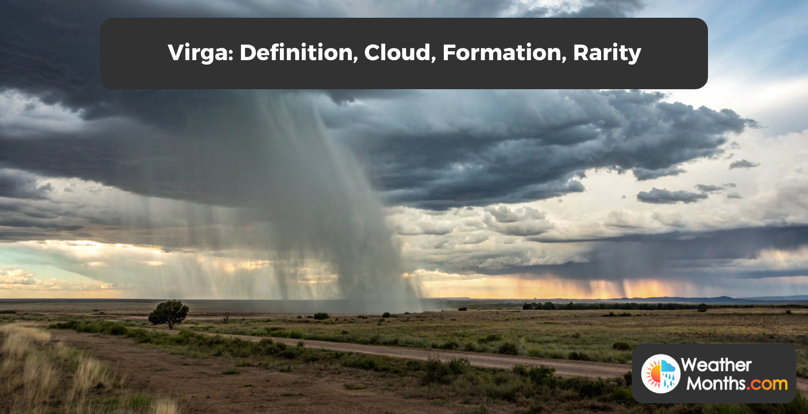
Virga formation involves precipitation falling from clouds and encountering dry air layers below. Evaporation creates a streak or tail extending from the cloud base, resembling stretched cotton candy or jellyfish tentacles. Air layers with temperatures ranging from 15°C to 25°C (59-77°F) and humidity below 30% cause evaporation or sublimation of precipitation. Rain evaporates within hundreds of meters of the cloud base, while ice particles sublimate within tens of meters.
Virga is not rare, with its frequency varying by region. Studies confirm the prevalence of virga in areas. Research published in the Journal of Applied Meteorology and Climatology found virga occurs in 30% of precipitation events in the southwestern United States. A study in the Journal of Hydrometeorology discovered virga is responsible for 20% of precipitation events in the Middle East.
Countries with virga include those in arid and semi-arid regions. North Africa, Australia, and North America experience frequencies of virga. Middle Eastern countries such as Saudi Arabia, Iran, and Iraq observe virga. Morocco, Algeria, and Tunisia see virga during summer months. Western United States states like Arizona, California, Nevada, New Mexico, and Texas experience virga . Canadian Prairies observe virga during summer thunderstorms.
What are virga showers in weather?
Virga showers occur when precipitation falls from clouds but evaporates before reaching the ground. Falling rain encounters dry air layers in the atmosphere, causing evaporation. Clouds produce rain that never reaches the surface. Dry conditions below clouds prevent precipitation from reaching the ground during virga events.
Arid and semi-arid climates experience virga showers due to low humidity and high evaporation rates. Dry surface air causes evaporation of falling droplets, with evaporation rates reaching 10-20 mm/h (0.4-0.8 inches/h). Types of precipitation form virga showers, including rain, snow, and drizzle. Cumulus or stratocumulus clouds generate virga showers, with cloud bases ranging from 500-2,000 meters above ground. Gusty winds accompany virga showers at ground level, resulting from downdrafts as precipitation evaporates.
What is a virga microburst?
Virga microbursts occur when collapsing virga clouds create downdrafts. Air sinks at speeds up to 97 km/h (60 mph), causing turbulence and strong winds. Water vapor condenses, producing rainfall. Severe thunderstorms generate these microbursts. Aircrafts face danger due to sudden changes in air speed and direction.
Virga microburst formation begins with evaporating precipitation cooling the surrounding air. Cooled air becomes denser and sinks towards the ground. The downdraft accelerates as it approaches the surface, reaching speeds up to 60 knots. Upon impact, the downdraft spreads out horizontally, creating a burst of winds.
Virga microbursts pose hazards due to sudden wind shifts and speed increases. Aircrafts face danger during takeoff and landing from virga microbursts. Wind gusts from virga microbursts cause property damage on the ground, including downed trees and structural damage.
How is virga formed?
Falling precipitation from clouds encounters dry air layers below. Precipitation evaporates before reaching the ground due to low humidity. Evaporation creates a streak or wispy tail extending from the cloud base. Dry air prevents rain from reaching the surface. Virga forms as a cloud streak without producing ground-level precipitation.
The air layer has temperatures ranging from 15°C to 25°C (59-77°F) with relative humidity below 30%. Falling precipitation encounters these dry conditions, causing evaporation or sublimation. Rain evaporates within hundreds of meters of the cloud base. Ice particles sublimate quickly, within tens of meters.
Precipitation rates in virga clouds range from 1-5 mm/h (0.04-0.2 inches/h). Raindrops or ice crystals fall further before evaporating. Virga appears as trails extending downward from the cloud base. These streaks resemble stretched cotton candy or jellyfish tentacles.
Virga occurs in arid or semi-arid regions with low humidity and high temperatures. Coastal areas experience virga when dry, cool air causes precipitation evaporation. Virga weather is associated with fair conditions and high-pressure systems. Temperature inversions create conditions for virga formation by trapping dry air near the surface.
Why is virga dangerous?
Virga poses dangers through microbursts and severe turbulence. Microbursts cause downdrafts, leading to wind shear and aircraft lift loss. Sinking air from virga creates microbursts. Transitions between virga areas and clear air generate severe turbulence zones. These phenomena threaten aviation safety and endanger people on the ground.
Virga extends kilometers from cloud bases, presenting a ranging hazard to aircraft. Microbursts associated with virga produce windshear up to 100 knots (185 km/h) and turbulence up to 50 feet per second (15.2 meters per second). Downdrafts created by virga reach speeds of 20 knots (37 km/h) and extend for kilometers. Virga effects include turbulence, icing, and windshear, impacting both aviation safety and weather conditions. Accidents have occurred due to windshear caused by virga-related phenomena.
How rare is virga?
Virga is not rare. Frequency varies by region. Arid and semi-arid areas like the Middle East, North Africa, and Western Australia experience virga. Canadian Prairies see virga during summer thunderstorms. East Australia observes virga in northern parts. North Australia experiences virga, except during strong thunderstorms.
Studies confirm the prevalence of virga. Virga appears in up to 70% of thunderstorms in some regions.
Virga clouds form in different environments. Virga is seen near mountains, coastlines, and urban areas. Virga occurs and is associated with thunderstorms, strong winds, and low humidity. Virga forms in regions with low humidity and high evaporation rates. Virga appears as a streak of cloud extending from thunderstorms or cumulus clouds.
What countries have the most virga?
Virga occurs in North Africa, Australia, and North America. Deserts, Western United States, and Canadian Prairies experience high frequencies of virga. Middle Eastern countries like Saudi Arabia, Iran, and Iraq observe virga. Morocco, Algeria, Tunisia, Arizona, California, Nevada, New Mexico, and Texas see virga during summer months.
The countries with the most virga are listed in the table below.
| Country | Percentage of Summer Precipitation as Virga | Regions Noted for Virga | Average Annual Precipitation (mm) | Virga Frequency (days/year) |
| United States | 35% | Western and Southwestern States (Arizona: 38%, New Mexico: 32%, Texas: 30%) | 400 | 60 |
| Canada | 15% | Canadian Prairies (Alberta: 18%, Saskatchewan: 12%) | 300 | 30 |
| Saudi Arabia | 55% | Najd Region (60%), Hejaz Region (50%) | 50 | 80 |
| United Arab Emirates | 58% | Abu Dhabi (60%), Dubai (55%) | 120 | 90 |
| Qatar | 52% | Doha (55%), Al Wakrah (50%) | 75 | 85 |
| Australia | 45% | Western Australia (50%), Northern Territory (40%) | 250 | 70 |
| Morocco | 25% | Marrakech-Safi (28%), Fez-Meknes (22%) | 400 | 50 |
| Algeria | 22% | Oran (25%), Algiers (20%) | 350 | 45 |
| Tunisia | 28% | Tunis (30%), Sfax (25%) | 300 | 55 |